
Use the Corcoran Street Directory
A useful Corcoran address search begins with a precise address. The goal is to identify the parcel before drawing conclusions about a person. Address text can point to a property, but the record trail may separate the physical site, tax mail, deed identity, and people who appear in older sources.
Keep the assessor parcel number (APN) with every later search. It reduces same-name errors and helps match the Kings County assessor, GIS map, recorder, and permit file to one parcel. The sequence below keeps current property evidence separate from household and historical clues.
- Fix the address. Write the full street text and city, then note whether the question concerns a site, a tax record, or a past household.
- Find the APN. Run the street address through the free Kings property search. Vacant parcels may need an APN because they lack a usable site address.
- Check assessor detail. Use the APN to reach current ownership, mailing, transfer, and legal-description data through the paid service or the assessor counter.
- Walk the map. Open the county parcel viewer, click the target polygon, and then click parcels that touch or face it.
- Follow the recorder trail. Search the current owner as grantee, the party receiving the recorded interest. Inspect the acquisition document on microfilm, then search the seller as grantor, the transferring party.
- Add lawful history. Pair deeds with Polk volumes, census schedules, assessment rolls, and Sanborn sheets, noting each source's limits.
My Voter Status is not a public street step. It authenticates one voter with private identifiers. Use it for the voter's own record, not as a list of Corcoran addresses.
Corcoran Street Directory Records by Address
Address-keyed records answer different parts of a street question. A parcel map locates land. A situs is the parcel's physical location, while a legal description is the deed's land identity. An assessor record connects the APN to value and, through paid or counter access, richer ownership fields. A recorder instrument documents a legal transfer. A permit file dates work at a site. Historical directories and census schedules may identify occupants for a particular year.
| Record Set | Keeper | Address Evidence | Access |
|---|---|---|---|
| Property search | Kings County Assessor | APN, street address, current value; richer ownership and history by paid or counter access | Free APN/address search; detail by subscription or counter |
| GIS parcel map | Kings County Assessor | Primary situs, APN, parcel shape, boundaries and map layers | Free weekly viewer; owner not shown |
| Recorded instruments | Kings County Clerk/Recorder | Grantor/grantee, recording date, document type, APN, legal description and mailing fields | Internet disabled; counter index and microfilm |
| Permits and code files | Corcoran City offices | Site, APN, applicant or owner, project, inspections and case dates | Precise written request; no verified public search |
| Historical sources | Libraries, National Archives and State Archives | Occupants, assessments, building form and street context by era | Years and access vary; gaps remain |
| Voter status or file | California Secretary of State and Kings Elections | One voter's status and address, or an approved-use file | Private self-lookup; Elections Code restrictions |
The APN is the bridge. The Corcoran street directory is strongest when that key travels from the Kings County property search to the recorder counter, then meets the exact site address in a city request. No source alone is a complete resident list, and a recorded party is not automatically an occupant.
Corcoran Street Directory APN Search
The free Kings County property tool publishes two search keys: APN and street address. Its current ParcelQuest path supplies the current map and secured-roll value. It is not advertised as a free public owner-name search. Ownership history, exemptions, transfer history, physical characteristics, brief legal description, situs, and tax data belong to the paid subscription or an assessor-counter request. A dated schedule lists 600 hits per year for $100 or unlimited use for $600, with an added user at $60; confirm current terms.
| Field | Type | Required | Format or availability |
|---|---|---|---|
| Assessor Parcel Number | Text | One search key | Needed for vacant land; format meaning is not published |
| Street Address | Text | One search key | Published alternative to APN |
| Owner name | Unavailable in free published search | Not applicable | Counter or subscription only |
| ZIP | Not verified | Not applicable | No published ZIP-wide mode |
Use the free result as a locator, not as final proof of title. The assessor warns that mapped parcel lines are assessment representations, not surveys. A paid or counter record can add more fields, but the tax mailing address may be a PO box, business, trustee, representative, or former address.
The Weekly Corcoran Street Map
A useful quirk in the Corcoran by-address workflow is that the free Assessor Parcel Web Map updates weekly while exposing only the primary situs and APN. That narrow output is still enough to move along a street, confirm parcel identity, and select adjacent polygons without mistaking the map for an owner roster.
Use the Kings County parcel GIS page or its official ArcGIS web map. Pan, zoom, and click the parcel. Layers add streets, city boundaries, sphere of influence, zoning, general plan, school and service districts, airport, septic, electric, Federal Emergency Management Agency (FEMA) flood, and fire-hazard context. No ZIP filter or downloadable street-browse result was verified.
Corcoran Street Address Keys
Three address labels often appear in one Corcoran record trail. The situs is where the assessed parcel sits. The mailing address receives tax correspondence. The legal description identifies the land in a deed. They can match, but they serve different purposes and should not be swapped during an address search.
- Parcel
- An assessment unit identified by an APN. The mapped outline is for assessment use and is not a survey.
- Situs address
- The physical location assigned to the parcel for assessment and site context.
- Mailing address
- The destination for tax correspondence. It may point away from the site and does not prove who occupies it.
- Legal description
- The deed identity for the land, often using a lot, block, subdivision, or other recorded reference.
- Plat
- A recorded or mapped lot-and-block reference that can help connect an older deed to the parcel.
- Criss-cross directory
- An address-order directory when a volume includes that section. No exact Corcoran run was verified.
The USPS Corcoran facility listing supplies postal context at 917 Chase Avenue and verifies ZIP 93212. Its retail hours are Monday through Friday from 9 to 1 and 2 to 4, with PO boxes accessible 24/7. Postal validation is useful before a property search, but a ZIP label does not define a parcel or a city boundary.
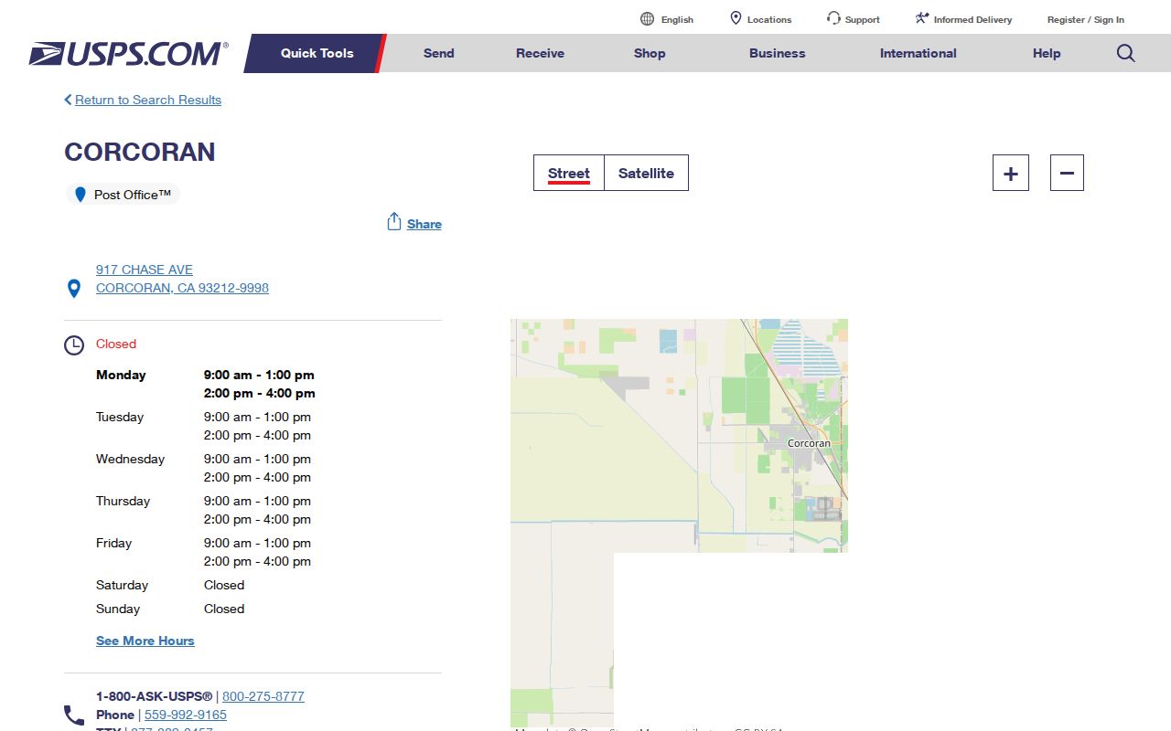
The postal listing confirms one verified Corcoran ZIP, not a property owner, household, or street-level resident directory. Use it to check the mailing part, then return to APN, situs, and legal-description fields.
Corcoran Deed Records After E-Recording
Kings County currently states that recorded documents, real-estate records, and related indexes are no longer available over the Internet. The change cites AB 1785 (2024) and Government Code sections 6254.21 and 7928.205. The older full-online-access material is superseded. Exact recorder index start, deed-book start, and imaging cutoff dates are not published.
For a Corcoran address trail, call the Kings County Clerk/Recorder at 559-852-2470 before traveling to 1400 W. Lacey Boulevard in Hanford. The Government Center is open Monday through Friday from 8 to 5, while recordings are accepted from 8 to 3. The public fallback is the counter index and office microfilm. Search the current owner as grantee, record the acquisition document and seller, then search that seller backward. A current schedule lists copies at $3 for the first page and $0.50 for each additional page, with $1 certification; verify the latest adopted schedule.
The 2026 recording schedule also lists $13 for the first page of a non-real-estate-fraud instrument or $16 for an associated-title instrument, $3 for each additional page, a $75 SB 2 fee unless exempt, and $1 for e-recording. The SB 2 charge is capped at $225. These figures should be checked against the latest adopted schedule before payment.
Timely comparison. The new recording system entered production April 8, 2024, and e-recording agreements were completed in August. About 70 to 80 percent of monthly instruments were e-recorded, but electronic recording is submission technology, not public online deed access. The county reported 21,388 recorded instruments in 2024, including 3,968 deeds and 3,200 deeds of trust.
Corcoran Street Permit Records
Corcoran Building/Safety does not publish a searchable permit register. The 2021 single-family permit packet places the counter at City Hall, 832 Whitley Avenue, 559-992-2151, with representative hours Monday through Friday from 8 to 11 and 1 to 4. Building Official appointments and inspection requests are separate. Inspections are listed for Tuesday and Thursday.
Request a permit jacket through the Corcoran public-record request form using the exact site address, APN, record type, and date span. Ask for permit number and type, applicant or owner, contractor, project description, valuation, issue and final dates, inspection history, and final status. The form shows a $0.20 per-page copy charge and a ten-day determination promise. Under the California Public Records Act (CPRA), unusual circumstances can allow a written extension of up to 14 days. Code files are also request-only and may redact complainant or investigative detail. For an unincorporated parcel, confirm the boundary and ask Kings Community Development, Building 6, 1400 W. Lacey Boulevard, 559-852-2670; hours are Monday through Thursday 8 to 5 and Friday 8 to noon.
Corcoran Historical Street Sources
Printed directories can supply household clues after the current parcel is fixed. The verified Tulare Public Library inventory lists R.L. Polk Hanford-Corcoran-Lemoore editions for 1967, 1970, 1978, 1986, and 1991. Regional Kings-Tulare runs are listed for selected periods from 1959 through 2010, but Corcoran inclusion must be checked edition by edition.
The Tulare genealogy inventory is the shelf lead, while the California State Library directory database offers City and County Directories and telephone books. No verified Corcoran page image, abbreviation key, reverse-section run, or local obituary microfilm run was found. The longer collection method belongs with the Corcoran city directory records, not an assumed reverse index.
Kings County formed in 1893 from western Tulare County, so earlier Corcoran-area material may be cataloged under Tulare. For earlier street context, the California State Archives lists Kings assessment rolls from 1893 to 1946, treasurer records from 1893 to 1944, and miscellaneous records from 1893 to 1969. NARA's 1950 Kings search describes Corcoran enumeration areas bounded by Whitley, Letts, Sherman, Chase, and King streets. The 1950 census is the newest public federal census until 2032. Those sources show different kinds of evidence, so a gap in one does not prove a vacant address.
Corcoran Sanborn Street Evidence
Sanborn sheets add a building and street layer to a Corcoran address search. Verified local coverage is 1912 with two sheets, 1928 with seven, and a 1942 revision with seven. The maps show footprints, materials, use, outbuildings, and street layout. They do not name every occupant.
Use the Library of Congress Sanborn search guidance to locate the available sheets, then compare the street label and parcel shape with deeds, legal descriptions, directories, and city maps. No official Corcoran street-renumbering table or date was verified. A suspected change needs cross-checking, not a guessed conversion.
Corcoran Voter Status, Not a Street List
The common voter-lookup myth is simple: an individual status page is not an open list of Corcoran streets. California My Voter Status asks for first name, last name, birth month, day and year, California driver-license or identification number, and the last four Social Security digits. A successful self-lookup can show status, party preference, registration address, precinct, vote-by-mail, ballot-status, and election information for that voter.
California Elections Code section 2194 keeps affidavit information confidential except for approved election, scholarly, journalistic, political, or governmental purposes. Driver-license or ID numbers, Social Security numbers, and signatures are not released. A full-file request asks for requester identity, scope, geography, permitted-use category, access controls, nondistribution agreement, documentation, and payment. The current fee and media wording were not verified.
What Corcoran's Street Directory Cannot Show
A careful address reference does not reveal every person connected to an address. The free map lacks owner names. The assessor's richer data require subscription or counter access. Non-owner occupants, other household members, DMV address data, and utility customer names do not appear as an open street list. A grantor or grantee role proves a recorded party role, not occupancy.
Nor is there a verified ZIP-wide export, public voter-by-street browse, exact reverse-directory run, or online Kings deed index to fill those gaps. The lawful fallback is a narrow request to the actual custodian, with an address or APN, record type, and date range. CPRA Government Code section 7920.000 et seq. does not require an agency to create a new list or override a confidentiality statute.
Lawful use. Corcoran address records are for personal, lawful research. Public access is not consent to track, threaten, impersonate, or harass anyone; California stalking and civil-harassment laws still apply.
Qualifying survivors and reproductive-health participants may use California's Safe at Home address-confidentiality program. Treat a missing record as an access limit or a clue to verify, never as proof that a person or household is absent.