
Corcoran Previous Residents Era Map
The previous residents of a Corcoran address appear in different record families. The Kings County Clerk/Recorder can point to owners and recorded transfers, but Internet land indexes are unavailable. The assessor connects a current parcel to its APN, situs, value, and, through a subscription or counter request, richer ownership and transfer history. Historical directories, census schedules, assessment rolls, Sanborn sheets, permit jackets, probate, and obituaries answer different questions. The verified Corcoran coverage map keeps the gaps visible.
| Source | Years It Covers | Where Held | What It Shows |
|---|---|---|---|
| Kings deed index and microfilm | Post-1893 jurisdiction; recorder start not published | Kings County Clerk/Recorder counter, Hanford | Owners, transfers, APN, legal description, address fields |
| Current assessor roll | Current fiscal year | Kings Assessor tools, subscription, or counter | APN, situs, value; richer ownership and history |
| State Archives assessment rolls | 1893-1946 | California State Archives and microfilm | Assessed person, property, and value |
| R.L. Polk Hanford-Corcoran-Lemoore | 1967, 1970, 1978, 1986, 1991 | Tulare Public Library Genealogy Room | Named listings; exact entry schema needs inspection |
| Kings-Tulare regional directories | 1959-62; 1964-67; 1968-71; 1972-88; 1989-90; 1991-92; 1994-95; 1997; 1998-2005; 2007-10; also Tulare-Kings 1997 and Kings County 1999 | Tulare Library; verify edition contents | Potential address, phone, and occupant clues |
| Federal census | Through 1950; newest public census until 2032 | NARA Kings County search | Enumerated occupants, relationships, and addresses |
| Corcoran Sanborn maps | 1912 (2 sheets); 1928 (7); 1942 revision (7) | Library and Library of Congress discovery channels | Building footprints, materials, use, and street layout |
| Corcoran permit files | Archive start not published | City Building/Safety and City Clerk request | Projects, applicants, inspections; not a full occupant list |
Use the source that matches the question. A title trail is strongest for ownership, but it is not proof that someone lived at the parcel. A directory or census entry is an occupancy clue, yet a missing name can reflect a move, an omission, a rural route, an institutional count, or a publication gap. Sanborn maps and permits date the building and its changes. Probate and obituary evidence can connect a past resident to relatives or an estate. No single Corcoran collection is a complete list of everyone who lived at one address.
Note: The recorder’s counter and microfilm route is essential because the county does not publish a verified Internet deed-index start year.
Corcoran Deed Records Backward
Begin with the present parcel, not a guessed name. The free Kings County Assessor property search accepts an APN or street address. Vacant land may require the APN. The free route supplies a current map and current secured-roll value, but it is not a free owner-name directory. The county’s full assessor access information describes subscription or counter data that can add current ownership, ownership history, exemptions, transfer history, physical characteristics, a brief legal description, situs, tax values, and other assessments.
Keep situs and mailing address apart. Situs is the assessed property location. Mailing address is where tax correspondence goes and may be a post-office box, business, trustee, representative, or former address. A mailing match can help locate a record, but it does not prove that the owner occupied the Corcoran parcel. The assessor, recorder, and tax collector also hold different kinds of evidence, so a tax bill is not a deed and a deed is not an occupant list. Assessor questions can go to 559-852-2486 or Assessor@co.kings.ca.us; the Tax Collector at 559-852-2479 handles tax inquiry, payment, and delinquency matters.
- Search the exact Corcoran street address or APN in the free assessor tool and save the primary situs and parcel number. Use the county map to check that the parcel is the intended one.
- Use the assessor counter or subscription route for the current owner, mailing address, legal description, and transfer history. Write down lot, block, subdivision, and APN details before leaving the current roll.
- Call the Kings County Clerk/Recorder at 559-852-2470 before traveling to 1400 W. Lacey Blvd. in Hanford. Ask how a name, APN, and date search is handled in the public-access room.
- Search the current owner as grantee in the recorder index. Record the document number, recording date, document type, grantor, APN, legal description, and return or tax-statement address, then request the office microfilm image.
- Take the seller named as grantor and search that person or entity as grantee. Repeat the same comparison for each earlier deed, checking the legal description and APN at every link.
For previous residents, the recorder’s current access notice says recorded documents, real-estate records, and related indexes are no longer available over the Internet. The county cites AB 1785 and Government Code sections 6254.21 and 7928.205. The older full-online FAQ is historical and superseded. Actual instrument images remain an office microfilm matter, while counter or mail copy requests follow the current schedule. The recorder’s index start, deed-book start, and imaging cutoff are not published, so a failed online search cannot be treated as an earliest year.
The shared Government Center is open Monday through Friday from 8 to 5; recordings are accepted 8 to 3, and certificates or other requests are handled 8 to 4. The current master copy schedule lists $3 for the first page, $0.50 for each additional page, $1 for certification, and self-printing at $1 for the first page plus $0.50 for each additional page. Verify the latest adopted schedule before requesting copies.
Genealogy catalog entries may help identify possible microfilm, but image restrictions and the original custodian must be confirmed. A city Public Records Act request is not a substitute for the county deed counter.
- Grantor and grantee
- The grantor transfers or releases an interest. The grantee receives it. In a purchase deed, the seller is usually the grantor and the buyer the grantee, but the roles depend on the instrument.
- Chain of title
- A linked sequence of recorded transfers that connects a present interest to earlier owners. Each link needs a document and a matching parcel identity.
- Legal description
- The formal parcel wording in a recorded instrument, such as a lot, block, subdivision, or other land description. It can preserve the link when street text shifts.
- Index and image
- An index is a pointer to a document. The recorded image is the instrument itself. Kings County’s current image route is office microfilm, not a public remote screen.
- Criss-cross directory
- An address-ordered section that may connect a street entry to a named listing. No verified Corcoran year run or exact section convention was located.
Note: Search the seller as a later grantee only after the current deed’s legal description and parcel number agree with the present Corcoran parcel.
Corcoran Address Identity and Past Residents
Street text is a useful lead, not a durable historical key. Carry the APN, lot or block, subdivision, and legal description through every Corcoran record search. Kings County requires APNs on the face of current real-property instruments, while older books may rely more heavily on a legal description. The situs address identifies the physical assessed location; the tax mailing address identifies correspondence; the legal description identifies the parcel in the deed. Those fields may point to the same place, but they do not mean the same thing.
No official Corcoran house-history guide, street-renumbering table, or verified reverse-directory year run was found. Do not supply a renumbering year or assume that two similar street entries are the same parcel. For a suspected change, compare Sanborn street labels, deeds, legal descriptions, directories, city maps, and a focused City Clerk or Planning request. A public-record request may locate a map or permit reference, but it cannot require an office to create a missing historical index.
Address trail: street text → APN → legal description → current deed pointer → prior grantor → earlier directory or census address.
Note: A street-number mismatch is a reason to compare parcel identity and map context, not a reason to invent local renumbering history.
Corcoran Directory Years for Past Residents
For previous residents, the strongest verified Corcoran shelf is the Tulare Public Library Genealogy Room. Its official directory inventory lists R.L. Polk Hanford-Corcoran-Lemoore editions for 1967, 1970, 1978, 1986, and 1991. Regional runs labeled Kings-Tulare cover 1959-62, 1964-67, 1968-71, 1972-88, 1989-90, 1991-92, 1994-95, 1997, 1998-2005, and 2007-10. The inventory also names Tulare-Kings Counties 1997 and Kings County 1999. The source PDF OCR displays 1888 for the 1972-88 run, an evident typo, so confirm the volume. Confirm Corcoran inclusion edition by edition, and do not assign R.L. Polk as publisher where the inventory only says Directory.
The California State Library City and County Directories database and its separate telephone-books collection are useful online alternatives. Search Kings, Corcoran, Hanford-Corcoran-Lemoore, and Tulare-Kings. Exact result years could not be extracted from the public interface. Corcoran Branch Library staff can check unadvertised local material, but its public pages do not promise a reverse directory, obituary index, newspaper microfilm, or a named database. For the collection-level details, the Corcoran city directory page keeps the shelf description together while the present trail uses only the years needed for one address.
Because no verified Corcoran directory page image was available from an official source, inspect the title page and abbreviation key before reading a listing. Record the entry exactly, distinguish a business from a household, and check whether that particular volume contains an address-ordered section. Compare 1967, 1970, 1978, 1986, and 1991 without assuming that a missing name proves a move or death. A publication gap, rural route, enumeration omission, or changed address can produce the same blank.
Corcoran Residents and Census Pairing
The National Archives 1950 Kings County search is the latest public federal census source for this trail until 2032 under the 72-year rule. Its Corcoran enumeration descriptions are bounded by Whitley, Letts, Sherman, Chase, and King streets. A census schedule records people as enumerated, with relationships and address context. It does not prove title, and a directory entry does not prove that a person stayed at the same address for the whole year.
- Choose a verified Corcoran directory year and copy the name, street text, and any address-order clue exactly as printed.
- Place that entry on the parcel trail by comparing APN, legal description, street layout, and the closest deed or assessment record.
- Open the 1950 Kings search and test the matching enumeration area, then note every person and relationship shown at the address.
- Compare the census household with the nearest Polk or regional directory year. Treat a new name, missing name, or changed number as a question for another source.
- Use deeds for ownership, assessment rolls for the taxable person and value, and obituary or probate records for a later family connection.
This directory-to-census process separates a named occupant clue from a legal transfer. It also shows why a house history can have two parallel lines: owners in deeds and people counted in households. The lines may meet, but they should not be merged without a matching address, date, parcel, or family fact.
Corcoran House History Records and Maps
The Library of Congress Sanborn search guidance supports a structural check for Corcoran addresses. Verified local coverage is 1912 with two sheets, 1928 with seven, and a 1942 revision with seven. The sheets can show building footprints, construction materials, use, outbuildings, and the street layout around a parcel. They can help test whether an address or structure existed in a given form, even when a directory is missing.
Sanborn maps do not name every resident. A footprint is not a deed, and a labeled use is not proof of who occupied the building. Pair the sheet with the legal description, APN, directory or census entry, and permit chronology. Library of Congress digitization is not complete for every sheet, including some 1923-30 material, so a discovery result may lead to a library or archive reference request rather than an image.
Corcoran Permit Records and Past Residents
Corcoran Building/Safety does not publish a searchable permit register. The 2021 permit packet places the counter at City Hall and lists representative hours Monday through Friday from 8 to 11 and 1 to 4, with the Building Official available by appointment. Inspection requests are due by 7 a.m., and inspections are listed for Tuesday and Thursday. A precise address or APN and a date range make a request more useful than a broad search for a name.
Use the city’s Corcoran public-record request form through the City Clerk. The form asks for the request date, contact details, address, a specific record description, page counts, and an estimated copy charge of $0.20 per page. A permit jacket may contain a work-site address, applicant or owner, project description, contractor, valuation, issue and final dates, and inspection chronology, subject to redaction. Those fields document a project, not every person who lived at the address.
For a parcel outside incorporated Corcoran, the alternate custodian is Kings Community Development, Building 6, 1400 W. Lacey Blvd., 559-852-2670. Its published hours are Monday through Thursday 8 to 5 and Friday 8 to noon. Establish the city or county jurisdiction before sending a request. The permit archive’s starting year is not published, so an old house may have construction evidence only through deeds, Sanborn sheets, assessment rolls, or a later permit reference.
Corcoran Recorder Records in 2024
Recent numbers explain why a modern recording system does not make a past-address search available from a home computer. Kings County put a new recording system into production on April 8, 2024 and completed electronic-recording agreements in August 2024. The county annual report records 21,388 instruments in 2024, including 3,968 deeds, 3,200 deeds of trust, 1,918 substitutions of trustee, 1,403 releases, 1,304 liens, and 1,241 abstracts. About 70 percent were electronically recorded.
Those figures describe digital intake by filers. They do not describe a public grantor/grantee index, a remote document viewer, or open image access. Kings County also removed Internet access to real-estate records and related indexes after the 2024 official-address privacy change. The public route therefore remains the free APN and map step, the assessor counter or subscription, and the recorder counter and microfilm step. An older online-access description should not override the current recorder notice.
Digital intake is not a public index. E-recording lets approved filers send instruments electronically. It does not let a Corcoran researcher browse the Kings County deed index or view the recorded image remotely.
Note: The 2024 instrument count measures recording activity, while a previous-resident search measures one parcel across several record systems.
Corcoran Foundational Records Preserved
Kings County recently reported preservation work on original government records from 1893 through 1977. Foundational books that had become dusty or crumbling were converted to a museum-preserved condition. That preservation story matters for a Corcoran house history because it protects the chance to consult an older record even when no digital index exists. It does not publish the recorder’s first year, create a reverse directory, or guarantee that every deed survived.
The California State Archives county holdings identify Kings assessment rolls from 1893-1946, treasurer records from 1893-1944, and miscellaneous records from 1893-1969, with some material on microfilm. Those series can bridge the years between the 1950 census and the later Polk volumes. Assessment names describe the taxable person or property, not necessarily every occupant. Search the archive catalog and ask reference staff about the exact series and access format.
Local memory sources add context but not a guaranteed name index. The Kings County Historical Society preserves county history and photographs, yet its online material does not provide an item-level finding aid, research fee, or complete resident index. A photograph, newspaper reference, or assessment entry should be cited by its source and date rather than presented as a complete household record.
Corcoran Before Kings County Records
Kings County formed in 1893 from western Tulare County, and territory was added from Fresno County in 1909. Hanford became the county seat. Corcoran incorporated on August 14, 1914. That creates a jurisdiction time switch for historical resident research: land and court material before 1893 may be cataloged under Tulare County, county records from 1893 forward belong in Kings searches, and city administrative files begin with the later incorporated-city record layer.
For a pre-1893 Corcoran-area event, search Tulare County catalogs before deciding that the record is missing. The Tulare directory inventory can help with later regional context, while the State Archives catalog can separate predecessor-county material from Kings series. No official recorder start year, first Corcoran printed directory, or exact street-renumbering history was located. A blank result at the wrong county or an unverified year is a research gap, not evidence that no person lived there.
Corcoran Previous Residents: Household Limits
Owners and occupants leave different traces. Deeds show a recorded property connection. Directories and the 1950 census show people as listed or enumerated. Assessment rolls show a taxable person and value. Permits show project roles and dates. Sanborn sheets show structures. None of those sources alone equals a complete occupant list. For a past resident who died, an obituary may name relatives, a service, or a burial place, while a probate file may identify a decedent, petitioner, heirs, property, and mailing addresses.
Probate is a court function, so use Kings Superior Court rather than the Clerk/Recorder for estate petitions and notices. Remote access to family and probate material is restricted under California Rule of Court 2.503, and court files may be destroyed under Government Code sections 68152-68153. Corcoran Cemetery, at 4170 Waukena Avenue, 559-992-3209, has no searchable interment database; a phone or written request can use a full name, approximate death or burial date, relatives, and plot details.
When a deceased former resident is the endpoint, California Health and Safety Code section 103526 is the controlling eligibility reference. The official source distinguishes authorized certified copies from certified informational birth, death, and public-marriage copies that any applicant may request. California does not use a verified simple 75-year or 100-year opening rule for these certificates.
The official California source image for that eligibility rule comes from the Health and Safety Code section 103526 page.
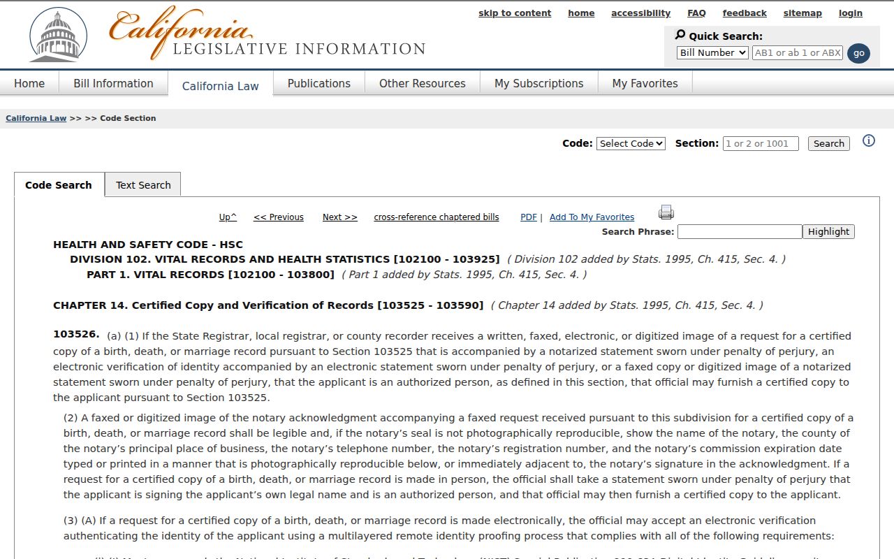
Use the authorized route only when the applicant qualifies, and use an informational copy for a permitted historical clue when appropriate. A confidential marriage record is limited to spouses or a court order under Family Code section 511. A divorce decree comes from the superior court; the CDPH Certificate of Record covers 1962 through June 1984 and is not the decree.
Lawful house history. Corcoran previous-resident research can support family history, property history, and personal curiosity. A public address is not consent to contact, follow, threaten, or impersonate anyone, and California law prohibits stalking and civil harassment.